About NYIMBA EXPLORATION PROJECT
Project Description
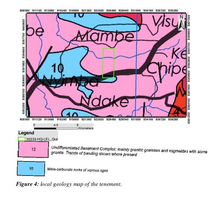
The license was granted on 07th March, 2022 to Gulf Drilling Limited, after which a certificate of the large exploration license was collected from the mining cadastre office. The area lies in the western part of the Mozambique belt. The prospect has a potential of hosting Gold, Zinc, Copper and molybdenum deposits. To unravel geological data and a continuation of exploration works Gulf Drilling Limited endorsed Tardis Mining solutions in 2024. The license encompasses an area of 1421.7353 hectares within Nyimba district eastern province of Zambia during Tardis Mining solutions involvement in 2024 some geological data was compiled based on reviews of Historical information from ZCCM-IH archives as well as from other historical documents held at the chamber of mines Library, in which some useful information were obtained from the Geological Survey Department in the ministry of mines and minerals Development. The tenement is predominantly underlain by meta-carbonate rocks in the southern section, overlain by undifferentiated Basement Complex, mainly composed of granitic gneisses and migmatites, with some banded granite. These formations cover approximately 90% of the tenement. Mapped mineralization in and around the license area includes Cu, Au, Mn, Pb, talc, and Zn. The primary focus of exploration is on gold, copper, and manganese deposits.
Project History
Geological studies conducted within and around the tenement have identified two distinct deformation phases: An early phase with flat, isoclinal folding. A later phase featuring asymmetric folding, indicating north to northwest tectonic stress directions, consistent with structural trends in the Irumide Belt.
LOCATION AND ACCESS TO THE TENEMENT
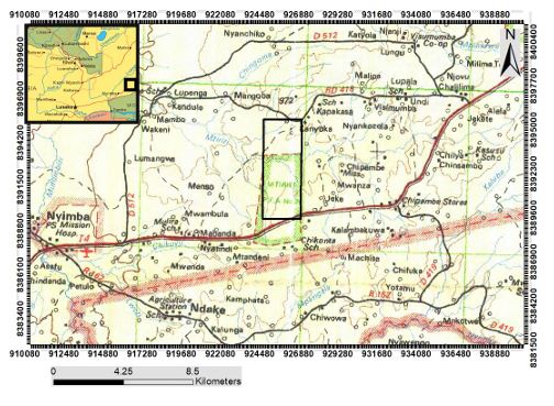
License No. 30333-HQ-LEL is situated entirely within Nyimba District, in the Eastern Province of Zambia (see Figure below). The license area is strategically located and readily accessible via the Great East Road (T4), which forms the southern boundary of the tenement. Access to the license area is obtained by following the Nyimba–Petauke section of the T4 Road, turning north at the junction located at coordinates 30.956570°E, -14.539635°S. The property lies approximately 15 km east of Nyimba town, allowing for efficient logistical support and proximity to local infrastructure. Geographic Coordinates and Elevation: Longitude Range: 30.93321°E to 30.95635°E Latitude Range: -14.48256°S to -14.53926°S Elevation: 400 m to 1050 m above sea level Coordinate Format: Decimal degrees Total Area: 1,421.7353 hectares
figures showing the tenement access

EXPLORATION HISTORY OF THE TENEMENT
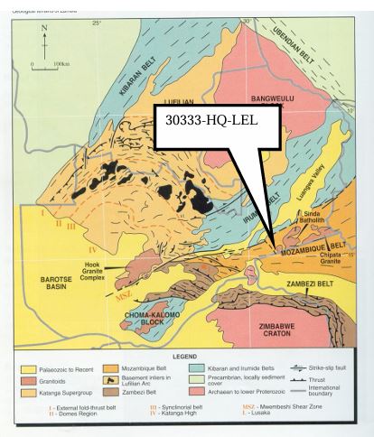
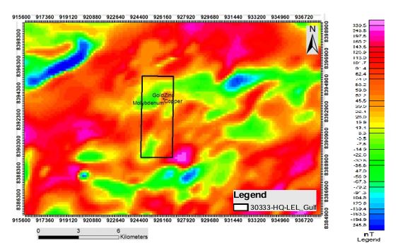
Geological studies conducted within and around the tenement have identified two distinct deformation phases: An early phase with flat, isoclinal folding. A later phase featuring asymmetric folding, indicating north to northwest tectonic stress directions, consistent with structural trends in the Irumide Belt. Aeromagnetic surveys have revealed several high-magnetic anomalies within the project area, which are often associated with gold, copper, zinc, and molybdenum mineralization.
Figures showing the geology and the Aeromagnetic survey surrounding the tenement

MINERALIZATION OF THE AREA
According to the 1:100,000 geological map by the Geological Survey Department of Zambia, mineralization indicators such as Cu, Au, Mn, Pb, talc, and Zn were recorded in nearby districts. While these deposits were not directly identified within the license area, the surrounding mineral occurrences suggest high potential. A geochemical soil sampling program conducted within the license area has confirmed the presence of gold mineralization, with concentrations ranging from <0.1 ppm to 1.4 ppm.
Mineral occurrence map showing potential minerals occurrences in the tenement.

GOLD DEPOSITS TYPES
The gold mineralization identified within License 30333-HQ-LEL exhibits characteristics similar to those found in the Lundazi region, with evidence of both reef (lode) and alluvial (placer) gold deposit types. Alluvial Gold Alluvial gold is primarily concentrated within tertiary sands, which are believed to be the product of weathering of meta-psammites and para-gneisses. These sands contain: Magnetite grains Sericite mica Kaolinite The presence of sericite and kaolinite suggests a possible genetic link between the alluvial deposits and the schistose fabric of underlying primary or epigenetic lode gold sources. Lode (Reef) Gold The lode gold occurrences are associated with strong silicification within meta-psammites, schists, and para-gneiss lithologies. Mineralogical and alteration features include: Silicification of the host rocks Hematization as a common alteration product Pyrite mineralization, indicative of hydrothermal activity These alterations suggest that gold was liberated from thiosulfate complexes during mineralizing events, potentially through oxidation and sulphide breakdown, consistent with epigenetic gold systems.
Mineral occurrence map showing potential minerals occurrences in the tenement

FUTURE EXPLORATION ACTIVITIES
The following exploration steps are planned to define and quantify mineralization within the tenement: Detailed geological mapping along stream exposures. Closer-spaced soil sampling (sampling intervals <100 m, sample stations ~50 m). High-resolution magnetic surveys to identify structural controls on mineralization. Trenching and exploratory drilling to assess sub-surface mineral potential. Mineral resource estimation and quantification. Community engagement and environmental/social impact studies to ensure sustainable operations.
Plan to Define the Mineralization
Gallery