About SERENJE EXPLORATION PROJECT
Project Description
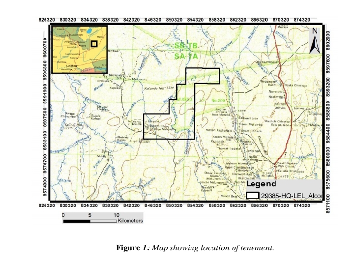
The license 29385-HQ-LEL was awarded on the 29th of December 2021 to Alcor International Limited after which, a certificate of the large exploration license was collected from the mining cadastre office. The license area lies in the central part of the irumide belt in which 1:100000 Geological mapping unravels the potential of the are in Hosting Qtz, Au, Co, Fe and manganese deposits. The license holders has interest in MN, Fe, Qtz and other minerals potential of the area. A quartz Area was identified South East of the tenement. The tenement lies in the irumide belt consisting of the Meta-quartzites of various ages which occur disseminated in the southern region of the tenement.the license 29385-HQ-LEL is located wholly within Serenje district, central province of Zambia, it can be accessed via Great North Road from Kapiri mposhi to the North, passing through Serenje. Approximately 40km from Serenje junction, after driving 20km on this road you will arrive at Mumba Village then from the village there's a 7km gravel road that leads to the tenement.
Project History
OVERVIEW
The license area 29385-HQ-LEL was given on 29th December, 2025 to Alcor International Limited after which certificate of the large exploration license was collected from the mining cadastre office. The tenement lies in the central irumide belt in which 1:100000 Geological mapping unravels the potential of the tenement to hosting Quartz, Gold, Cobalt, iron and manganese deposits. For the license holders to unravel the Geological Data, extending of exploration and for technical support they endorsed Tardis Mining solutions a Zambian registered company. The tenement lies in the irumide belt consisting of the Meta-quartzites of various ages which occur disseminated in the southern region of the tenement in which they are overlain by Quartzite-pelite sequence of rocks in the southern, southern eastern and north eastern parts of the tenement. These are overlain by the kundelungu undifferentiated which include the shales and sandstones which cover the western, northwest and northern regions of the tenement. In order for Tardis Mining solutions to unravel the Geological information, there was a use of Historical information from ZCCM-IH archives as well as from other historical documents held at the chamber of mines Library. And some useful information were obtained from Geological Survey Department in the ministry of mines and minerals Development.
Geology and location of the License area
GEOLOGICAL HISTORY OF THE TENEMENT
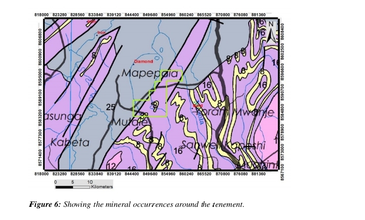
De Beers Prospecting (Zambia) limited conducted and extensive examination of the lamproite pipes and dykes in the area during the 1960's and Early 1970's , this study involved detailed geological mapping and sampling, leading to the identification of 14 individual pipes or groups of pipes and dykes( De Beers, 1973; Scott Smith et al., 1986). The Kasanka area, situated on the western side of the licensed area was reported to contain twelve kimberlite pipes aligned along two NORTH- trending structures. Apart from ancient workings, the predominant focus in the area has been on alluvial Gold. During the license period, Alcor International Limited conducted some exploration activities and identified several deposit of quartz and iron ore, consider the figure below.
Historical mapping information around the tenement
LOCATION AND ACCESS TO THE TENEMENT
The license area 29385-HQ-LEL is wholly within Serenje district central province Zambia, refer to the figure below. The tenement can be reached by taking the Great North Road from Kapiri mposhi to the North, passing through Serenje. Approximately 40km km from Serenje junction on this road, you will arrive at Mumba Village. From Mumba Village, there is a 7km gravel road that leads to the tenement
location of the License area
MINERALIZATION
From the 1:100000 Geological mapping done by the Geological Survey Department of Zambia, indications of mineralization were observed, the mapped mineralization include iron ore, gold and diamond though not economically viable. The license holder has interest in Manganese, iron ore, quartz and any other mineral potential of the Area. A quartz Area was identified by South East of the tenement and a Few, Co as well as Au area was identified on the central region of the tenement, in which both identified areas are pending for further exploration works.
Map showing identified mineralization
FUTURE EXPLORATION ACTIVITIES
Detailed geological mapping alongside stream exposures,Infill soil sampling to ascertain anomalies and establish their Significance. Detailed magnetic survey to identify structures that may control mineralization, Trenching on the anomalous MN zones.
Plan To Define the mineralization
Gallery