About Katete Exploration Project
Project Description
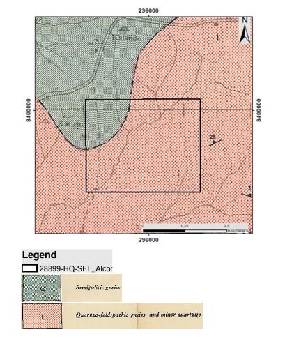
License No. 28899-HQ-SEL was granted to Alcor International Limited on 1st July 2021, and a certificate for the Large-Scale Exploration License was subsequently collected from the Mining Cadastre Office. The license area is located within the Mozambique Belt, a geologically significant region underlain predominantly by quartzo-feldspathic gneiss with minor quartzite units. These lithologies extend across nearly the entire tenement and are known to be favorable hosts for various mineralization types. Mineral Potential The license area is considered prospective for a range of commodities, including: Copper (Cu) Gold (Au) Graphite Cobalt (Co) Iron Ore (Fe) Lead (Pb) Nickel (Ni) Beryl Zinc (Zn) However, Alcor International Limited has identified gold (Au), feldspar (FLD), and quartz (QTZ) as the primary exploration targets within the license. To support data compilation and preliminary analysis, Alcor International Limited engaged Tardis Mining Solutions Limited in collaboration with MineHub Africa for technical and strategic support. Although limited modern work has been undertaken so far, the license holder is committed to advancing exploration activities in the area and unlocking its full mineral potential.
Project History
Most of the exploration in and around the license area was done by the Geological Survey Department of Zambia. Tardis Mining Solutions limited was endorsed by Alcor International Limited to perform some geological works and produce the Quarterly report for the license 28899-HQ-SEL.
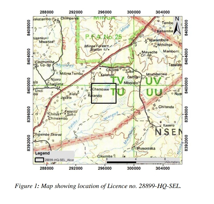
LOCATION AND ACCESS TO THE TENEMENT
License No. 28899-HQ-SEL is located within Katete District, in the Eastern Province of Zambia (see Figure below). The area is accessible via the T4 Great East Road, which extends from Lusaka to Nyimba Mission, covering a total distance of approximately 360 kilometers. From Nyimba Mission, access to the license area continues by branching off to the right at Chisambo onto a gravel road, which leads directly to the exploration site.
Location of the License Area
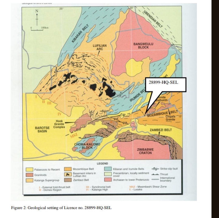
GEOLOGICAL SETTING AND DATA SOURCES
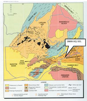
The license area lies within the Mozambique Belt, a region characterized by medium- to high-grade metamorphic rocks, including gneisses and schists, along with significant granitoid intrusions. Notable granite bodies in the region include the Chipata Granite, Chipalapata Granite, and the Sinda Granite, the latter being the youngest with an age of approximately 510 million years (Ma). This is considered a brownfield exploration area, meaning there is prior geological data and indications of mineral potential, though modern exploration has been limited. Historical data for the license area has been compiled from various sources, including: ZCCM-IH archives Chamber of Mines Library Geological Survey Department, under the Ministry of Mines and Mineral Development Most of the historical exploration work in and around the area was conducted by the Geological Survey Department, providing a foundation of baseline geological knowledge.
Figures showing the geology surrounding the tenement
MINERALIZATION OF TENEMENT AND MINERALIZATION TYPES IN THE MOZAMBIQUE BELT (Eastern Zambia)
The license area is prospective for a range of mineral commodities, including: Copper (Cu) Gold (Au) Graphite Cobalt (Co) Coal Iron Ore (Fe) Lead (Pb) Nickel (Ni) Beryl Zinc (Zn) However, the license holder has placed a strategic focus on exploring the potential for Gold (Au), Feldspar (FLD), and Quartz (QTZ) within the area. The Mozambique Belt hosts a variety of mineralization types, including: Magmatic Volcanogenic Hydrothermal Pegmatitic Placer deposits These mineralization processes are associated with specific rock types and host the following mineral deposits: Paragneisses and amphibolites: Zinc (Zn), Copper (Cu) Schists and metavolcanics: Gold (Au), Copper (Cu), Gallium (Ga) Quartz veins: Gold (Au), Copper (Cu), Bismuth (Bi)
Figures showing Mozambique belt and geology
FUTURE EXPLORATION ACTIVITIES
The following exploration activities are planned to advance the understanding of the geological potential within License No. 28899-HQ-SEL: Remote Sensing Survey Utilize satellite imagery and aerial data to identify geological structures, alteration zones, and surface anomalies. Geological Mapping Conduct detailed field mapping to define lithologies, structural features, and mineral occurrences. Geochemical and Geophysical Surveys Implement soil, rock, and stream sediment sampling, along with magnetic and resistivity surveys to identify subsurface anomalies. Target Selection and Trenching Define high-priority targets for trenching and conduct detailed surface investigations for mineralization indicators. Exploratory Drilling Execute drilling programs to test subsurface continuity, grade, and geometry of mineralized zones. Preliminary Resource Estimation Based on drilling results, carry out initial resource modeling and estimation to assess economic viability.
Plan to Define the Mineralization and exploration activities
Gallery